Electronic data collection and GPS on smart phones improves IRS planning, resulting in safer, easier spray campaigns.
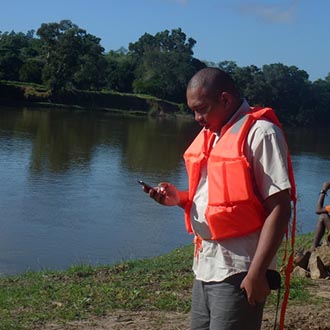
Environmental Compliance Officer Tahina Masihelison uses a smart phone to record a river crossing. Photo credit: Mijoro Rasolofomalala
Environmental Compliance Officer Tahina Masihelison uses a smart phone to record a river crossing. Photo credit: Mijoro Rasolofomalala
Transporting insecticide for indoor residual spraying (IRS) campaigns can be challenging in rural areas where there are multiple river crossings, inaccessible roads, and long distances between targeted spray areas. The President’s Malaria Initiative (PMI) Africa IRS Project conducts detailed geographical reconnaissance before spraying to map out areas targeted for IRS and ensures the safe transport and delivery of insecticide. The project collects information on the physical terrain, bodies of water, agricultural crops, and other environmental features. However, environmental compliance officers were finding inconsistencies and incomplete reporting in geo reconnaissance when the information was collected on paper forms.
In Madagascar, the PMI Africa IRS Project’s Monitoring and Evaluation Manager, Arnaud Rakotonirina, and Environmental Compliance Officer, Tahina Masihelison, developed electronic data collection forms for smart phones to improve data collection during geo reconnaissance, resulting in easier, faster and more accurate planning for IRS campaigns. Using the smart phone for geo reconnaissance enabled the project to introduce a free global positioning system (GPS) application for spatial data visualization, including complete and accurate information on distances between targeted spray areas and sensitive areas, such as organic crops.
“Conducting geo reconnaissance on the smart phone has simplified and accelerated how we collect information in the field, and has eliminated transcription errors and double entries when transferring information from paper form to an Excel sheet,” said Arnaud Rakotonirina.
The GPS application allows the project to identify in advance the sensitive areas to avoid during spraying, as well as areas inaccessible by car, thereby minimizing potential environmental risk. The GPS also indicates the nearest health care clinics if an accident should occur.
In May 2015, AIRS Madagascar used the smart phone for geo reconnaissance for the first time in the Farafangana District. In doing so, the project reduced the time needed to collect and enter data by half. Errors were reduced, and richer data, such as photos, GPS coordinates, and automatic date and time stamping, were collected, allowing for more time for analysis of IRS implementation strategies and environmental compliance risk and safety.